Forest and Tree Cover
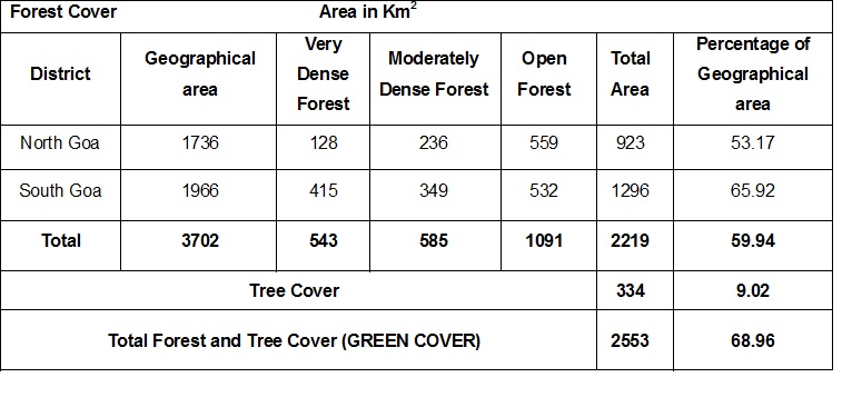
The Forest Survey of India (FSI) assesses the forest and tree cover of the country along with other resource parameters biennially using the remote sensing technology and is published in the State of Forest Report (SFR). As per the State of Forest Report published by the Forest Survey of India, the forest cover of the state is 2219 Km2 which is 59.94 % of the State’s geographical area. The estimated tree cover in the state is 334 Km2 whichis 9.02 % of the Geographical area. The district wise area in different density classes, the total forest and tree cover and the altitude Zone wise forest cover is given in the tables and charts below:


Altitude Zone - wise Forest Cover

The total estimated growing stock in the state as per the SFR 2013 is 10.33 million cum and the estimated bamboo bearing area of the state is 308 Km2.
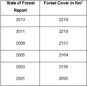
Forest Cover Assessments in the previous Years
RECORDED FOREST AREA
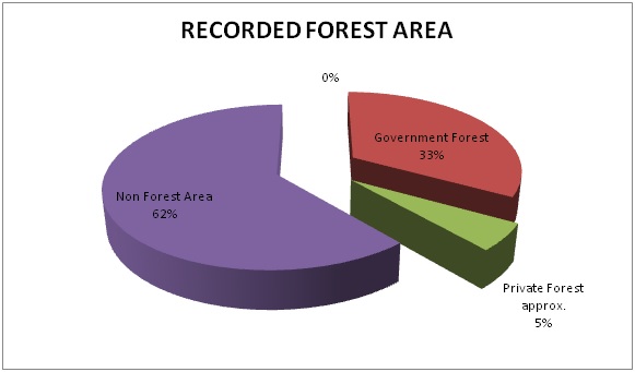
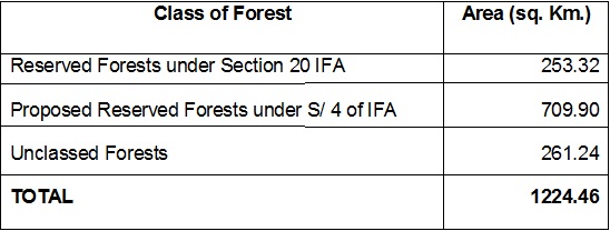
The total forest area of Goa is 1424.46 sq. km, out of which 200 sq. km approximately is privately owned. This amounts to 33.08% of the geographical area of Goa being government forest, and 5.40% being private forest. 61.52% of Goa’s geographical area is non-forest land

DISTRICT WISE FOREST AREA OF GOA

FOREST AREA BY LEGAL STATUS (sq. km)
FOREST TYPE CLASSIFICATION
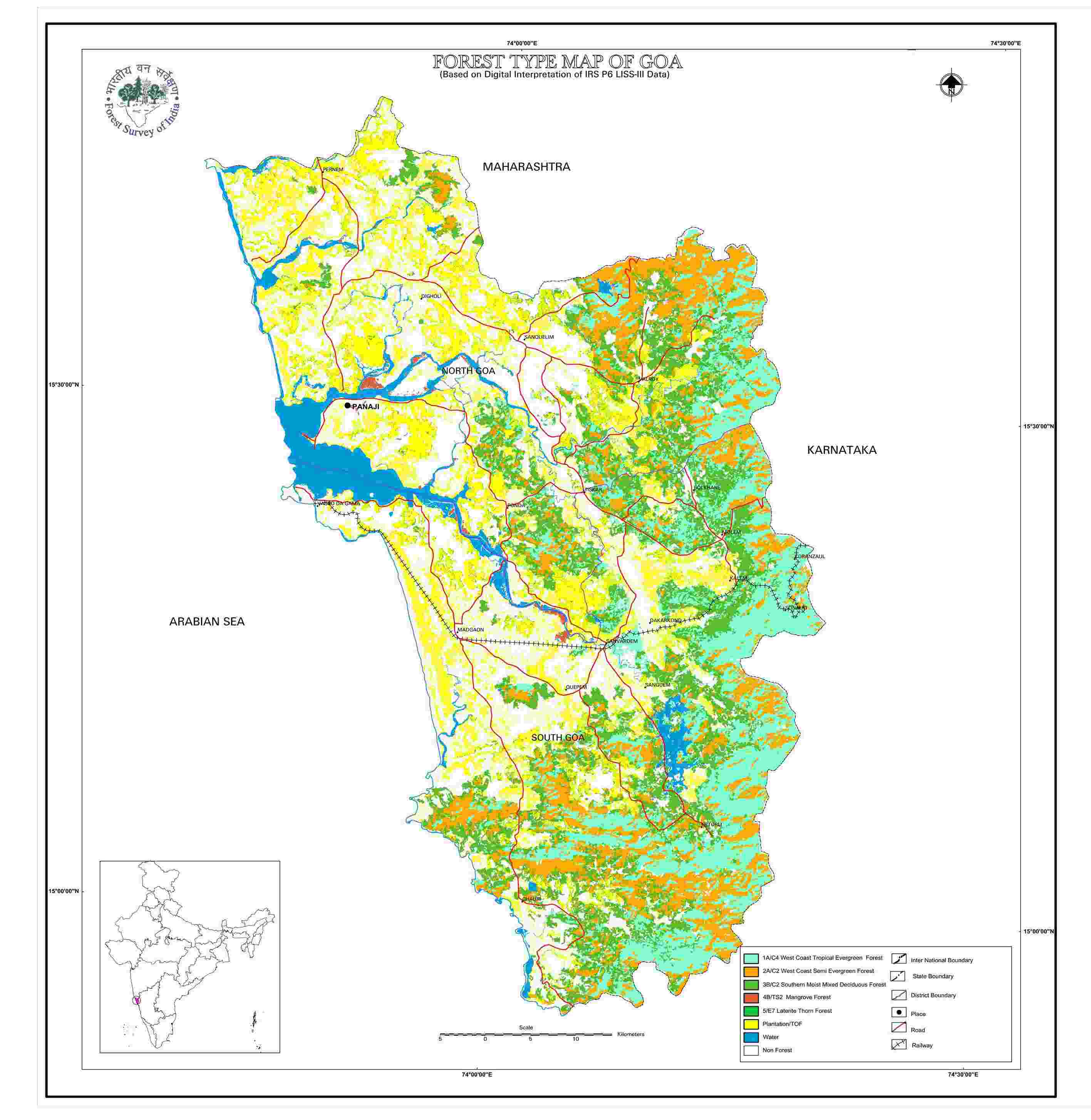
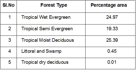
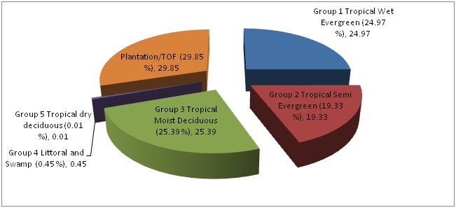
The Forest Survey of India has mapped the forest types in using satellite data with reference to Champion and Seth Classification. As per this assessment in the State of Forest Report 2011, the state has 5 forest types which belong to five forest type groups.
MANGROVES
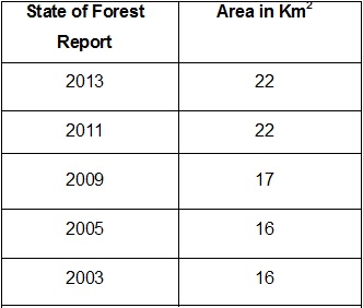
The mangroves are salt tolerant plant communities found along the tropical and sub-tropical tidal regions of the world between 24 degrees north and 38 degrees south latitudes. These ecosystems are rich in biodiversity and the mangrove vegetation exhibit a number of morphological and physiological adaptations in order to survive in such harsh conditions characterized by lack of oxygen, high salinity and frequent tidal inundation. As per the SFR report 2013, the area of the mangrove vegetation was 22 Sq.Km. The district wise and density wise area under mangroves in the state of Goa is given below
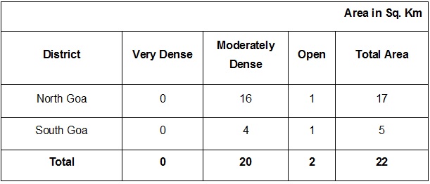
Mangrove Area Assessments in Previous Years as per SFR
